
Official name Mansfield Dam Opened 1941 | Opening date 1941 Width (base) 213 feet (65 m) Height 85 m Length 2,161 m Construction began 1937 | |
 | ||
Similar Lake Travis, Tom Miller Dam, Colorado River, Lake Austin, Longhorn Dam | ||
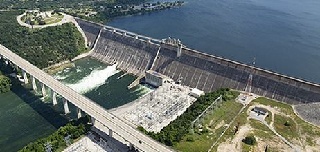
Mansfield Dam (formerly Marshall Ford Dam) is a dam located across a canyon at Marshall Ford on the Colorado River, 13 miles (21 km) northwest of Austin, Texas. The groundbreaking ceremony occurred on February 19, 1937, with United States Secretary of the Interior Harold L. Ickes attending. The dam was a joint project by the Lower Colorado River Authority (LCRA) and the United States Bureau of Reclamation, with the company Brown and Root the prime contractor. The dam was completed in 1941. Originally called Marshall Ford Dam, the name was changed in 1941 in honor of United States Representative J.J. Mansfield. The reservoir behind Mansfield Dam is named Lake Travis. The dam is owned and operated by the LCRA.
Map of Mansfield Dam, Austin, TX 78734, USA
Mansfield Dam is 278 feet (85 m) high, 7,089 feet (2 km) long, and 213 feet (65 m) thick at the base. The concrete gravity dam with embankment wings and saddle dikes was designed to control flooding; to store 1.4 km³ (369 billion US gallons) of water; and to generate hydroelectric power (108 megawatts). The Spillway Elevation is 714 feet above MSL. LCRA begins to open floods gates when water reaches 681 feet above MSL.
A two-lane highway, RM 620, crossed the top of the dam, but traffic congestion brought on by the growth of the city of Austin and expanded popularity of recreation at Lake Travis forced the state to build a four-lane highway bridge on the downstream side of the dam. Traffic is no longer allowed on the road across the dam, except for service vehicles.