
Population 5,547 (2006) Northeast (Mangere Inlet) West (Manukau Harbour) South Māngere Southeast Favona | North (Manukau Harbour) Southwest (Manukau Harbour) Northwest (Manukau Harbour) East Favona | |
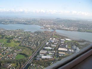 | ||
Mangere Bridge is an Auckland suburb under the local governance of the Auckland Council, at the south end of Mangere's bridge over the Manukau Harbour.
Contents
Map of Mangere Bridge, Auckland, New Zealand
It is home to Mangere Mountain and the Ambury Farm Park run by the Auckland Council, and backs onto rural land surrounding the Auckland Airport.
It is a multicultural area, often with large families, with the suburb dominated by brick-and-tile homes built in the 1960s-1970s.
Association football
Mangere Bridge is home to Onehunga-Mangere United football club.
References
Mangere Bridge, New Zealand Wikipedia(Text) CC BY-SA