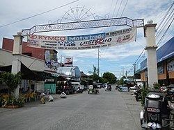
Country Philippines Founded 1837 Time zone PST (UTC+8) Local time Monday 9:31 AM | Region Ilocos (Region I) Barangays Area 317.5 km² Province Pangasinan | |
 | ||
District 2nd district of Pangasinan Weather 29°C, Wind SE at 14 km/h, 47% Humidity | ||
Manleluag hot spring mangatarem pangasinan
Mangatarem (Pangasinan: Baley na Mangatarem; Ilocano: Ili ti Mangatarem) is a 1st class municipality in the province of Pangasinan, Philippines. According to the 2015 census, it has a population of 73,241 people.
Contents
- Manleluag hot spring mangatarem pangasinan
- Map of Mangatarem Pangasinan Philippines
- Manleluag spring national park mangatarem pangasinan
- Tourism
- Barangays
- References
Map of Mangatarem, Pangasinan, Philippines
Mangatarem is a Pangasinan word for "mango plantation" The town's name also came from the Ilocano Phrase which means "mango and oyster".
The municipality is home to the Manleluag Spring Protected Landscape.
Manleluag spring national park mangatarem pangasinan
Tourism
Barangays
Mangatarem is politically subdivided into 82 barangays.
References
Mangatarem, Pangasinan Wikipedia(Text) CC BY-SA
