
Country Philippines Barangays ZIP code 2810 Local time Monday 2:05 AM | District Lone District of Abra Time zone PST (UTC+8) Area 111 km² Province Abra | |
 | ||
Region Cordillera Administrative Region (CAR) Weather 23°C, Wind SE at 5 km/h, 74% Humidity | ||
Bandila mayor ng manabo abra sumuko dahil sa droga
Manabo, officially the Municipality of Manabo (Ilocano: Ili ti Manabo, Filipino: Bayan ng Manabo), is a municipality in the province of Abra in the Cordillera Administrative Region (CAR) of the Philippines. The population was 10,761 at the 2015 census. In the 2016 electoral roll, it had 7,154 registered voters.
Contents
- Bandila mayor ng manabo abra sumuko dahil sa droga
- Map of Manabo Abra Philippines
- Etymology
- Geography
- Barangays
- Demographics
- References
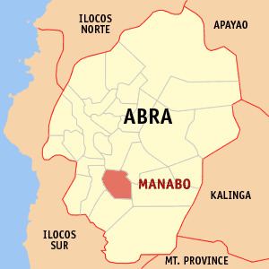
Map of Manabo, Abra, Philippines
Etymology
Upon hearing that a gobernadorcillo (the Spanish-era equivalent of a governor) was coming through the river from Cervantes, the natives in present-day Manabo welcomed him with a landing pad made of bamboo and a feast of meat, fruit and wine. On his departure later, the natives were so enthusiastic in seeing him off that they overloaded the bamboo landing pad and collapsed, in which everyone shouted, "Manabo! Manabo!" The Spanish gobernadorcillo, amused with the event, named the place "Manabo".
Geography
Manabo is located at 17°26′N 120°42′E.
According to the Philippine Statistics Authority, the municipality has a land area of 110.95 square kilometres (42.84 sq mi) constituting 7000266000000000000♠2.66% of the 4,165.25-square-kilometre- (1,608.21 sq mi) total area of Abra.
Barangays
Manabo is politically subdivided into 11 barangays.
Demographics
In the 2015 census, Manabo had a population of 10,761. The population density was 97 inhabitants per square kilometre (250/sq mi).
In the 2016 electoral roll, it had 7,154 registered voters.