
Population 972 (2006 census) Elevation 22 m Local time Sunday 7:36 PM | Postcode(s) 3892 Mean max temp Mean min temp Postal code 3892 | |
 | ||
Location 523 km (325 mi) E of Melbourne368 km (229 mi) S of Canberra150 km (93 mi) E of Orbost526 km (327 mi) S of Sydney86 km (53 mi) S of Eden (NSW) Weather 23°C, Wind N at 26 km/h, 88% Humidity Points of interest Gabo Island, Betka Beach, Mallacoota RSL Bunka Museum, Quarry Beach, Lake Barracoota | ||
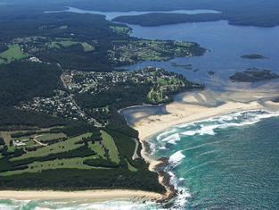
Mallacoota is a small town in the East Gippsland region of Victoria, Australia. At the 2006 census, Mallacoota had a population of 972. At holiday times, particularly Easter and Christmas, the population increases by about 8,000. It is one of the most isolated towns in the state of Victoria, 25 kilometres off the Princes Highway and 523 kilometres (325 mi) from Melbourne. It is 526 kilometres (327 mi) from Sydney, New South Wales. It is halfway between Melbourne and Sydney when travelling via Princes Highway, though that is a long route between Australia's two main cities. It is the last official township on Victoria's east coast before the border with New South Wales. Mallacoota has a regional airport (Mallacoota Airport) YMCO (XMC) consisting of a gravel runway for light planes and an asphalt runway for commercial planes flying from Melbourne.
Contents
Map of Mallacoota VIC 3892, Australia
It is known for its wild flowers, abalone industry, the inlet estuary consisting of Top Lake and Bottom Lake, and Croajingolong National Park that surround it. It is a popular and beautiful holiday spot for boating, fishing, walking the wilderness coast, swimming, birdwatching, and surfing. The Mallacoota Arts Council runs events throughout each year. Mallacoota Inlet is one of the main villages along the wilderness coast walk from NSW to Victoria, Australia.
History
Prehistory the area was part of the territory of the Bidawal people. Settlers started to arrive in the 1830s. A small timber lighthouse was installed on nearby Gabo Island in 1854, and the existing granite lighthouse was completed in 1862. By the 1880s commercial fishing was well established, with some catch being shipped south to Melbourne. At the same time the first tourists started to arrive. Gold was discovered in 1894, after which the Spotted Dog Mine operated for three years. Mallacoota Post Office opened on 7 May 1894 and Mallacoota West in 1901. In 1928 Mallacoota West was renamed Mallacoota, and Mallacoota became Mallacoota East (closing in 1940). A satellite airfield was constructed during World War II for the purpose of coastal defence. During the 20th century the logging, farming and fishing industries in the area declined, and the tourism and abalone industries grew. The town's largest employer, the abalone co-operative, was formed in 1967.
Sport
Golfers play at the course of the Mallacoota Golf and Country Club on Nelson Drive.
The Sydney Swans' 2005 premiership winning defender and current St Kilda player Sean Dempster hails from Mallacoota.
Whale watchings targeting for migrating and residential species such as the endemic, endangered Burrunan dolphins, Southern Right whales, and Humpback whales, are available on many locations along the coasts in their migration seasons.
Climate
Mallacoota has a subtropical climate (Cr) according to the Trewartha climate classification system or an oceanic climate (Cfb) according to Köppen system.