
Country Philippines Barangays ZIP code 2820 Province Abra | District Lone District of Abra Time zone PST (UTC+8) Area 283.2 km² Local time Sunday 2:50 PM | |
 | ||
Region Cordillera Administrative Region (CAR) Weather 26°C, Wind E at 10 km/h, 48% Humidity | ||
Malibcong, officially the Municipality of Malibcong (Ilocano: Ili ti Malibcong, Filipino: Bayan ng Malibcong), is a municipality in the province of Abra in the Cordillera Administrative Region (CAR) of the Philippines. The population was 3,428 at the 2015 census. In the 2016 electoral roll, it had 2,856 registered voters.
Contents
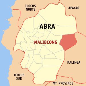
Map of Malibcong, Abra, Philippines
Geography
Malibcong is located at 17°34′N 120°59′E.
According to the Philippine Statistics Authority, the municipality has a land area of 283.17 square kilometres (109.33 sq mi) constituting 7000680000000000000♠6.80% of the 4,165.25-square-kilometre- (1,608.21 sq mi) total area of Abra.
Barangays
Malibcong is politically subdivided into 12 barangays.
Demographics
In the 2015 census, Malibcong had a population of 3,428. The population density was 12 inhabitants per square kilometre (31/sq mi).
In the 2016 electoral roll, it had 2,856 registered voters. The Itneg tribe can be found in Malibcong and they speak a sub-dialect of Banao Itneg language, and Ilocano. There are three dialects in malibcong: Banao, Gubang and Mabaka.