
Length 23 km | ||
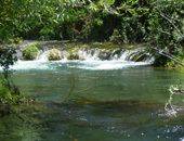 | ||
The Makaroro River is a river of the southern Hawke's Bay region of New Zealand's North Island. It flows southeast from the slopes of the Ruahine Range, meeting the waters of the Waipawa River 12 kilometres (7 mi) west of Tikokino.
Ruataniwha Water Storage SchemeEdit
(also called Tukituki Catchment Proposal)
The upper river is the proposed site for a dam to create a 93 million m³ storage reservoir. The project was proposed by the Hawks Bay Regional Council to ensure water sustainability for the region around the dam site. The Council created the Hawks Bay Regional Investment Company Ltd in 2013 to manage the project. Due to the nature of the Regional Councils relationship the resource consent was handled by the Environmental Protection Authority, and the Department of Conservation due to some of the land on the proposed site being part of the Ruahini Forest Park. After the initial approval in 2014, two appeals lodged by Hawke’s Bay and Eastern Fish and Game Councils and the Royal Forest and Bird Protection Society of New Zealand and cross appeal lodged by the Environmental Defence Society were examined by the High Court to reconsider the conditions of consent . On 12 December 2014 Justice Collins ordered the Board to reconsider their decision on an appropriate mechanism for managing the amount of Nitrogen that enters the Catchment Area and giving parties a fair opportunity to comment. The final decision was released 25 June 2015 which included some amendments to the previous consent conditions.