
Established 1876 Local time Saturday 3:13 AM | Postcode(s) 6443 Postal code 6443 | |
 | ||
Weather 20°C, Wind NE at 24 km/h, 52% Humidity | ||
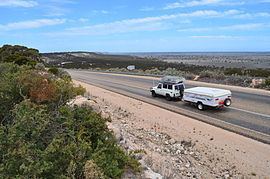
Madura is a small roadhouse community located on the Eyre Highway in Western Australia, on the Roe Plains. It is 1,253 kilometres (779 mi) from Perth. It is at the foot of the escarpment next to the Madura Pass down from the Nullarbor Plain.
Contents
Map of Madura WA 6443, Australia
History
Madura was settled in 1876 as a place to breed quality cavalry horses for the British Indian Army for use in the Northwest Frontier region of India (now part of Pakistan). The horses were shipped from the coast at Eucla. (Cervantes, north of Perth, was also used for breeding.) The site was chosen as it was one of the few with free flowing bore water in the area.
The surrounding area is part of Madura Station currently a sheep station, but was previously used to graze cattle, horses and camels.
Present day
Like other locations in the Nullarbor Plain area, the area consists of little more than a roadhouse, open 6:00am to 9:00pm each day. 2 km west of Madura is a scenic lookout with sweeping views of the Madura Pass across the escarpment and the Roe Plains. Natural blowholes may also be found nearby. The area is used for pastoral purposes, mainly sheep rearing. Surrounding Madura is the Madura Shelf stretching 265 600 square kilometres of predominately sedimentary rock, part of the Bight Basin which has been found to contain crude oil and geothermal gradients.