
Country United States County Carroll Time zone Eastern (UTC-5) Elevation 205 m Zip code 03849 | Incorporated 1852 Area code(s) 603 Area 106 km² Population 2,502 (2010) | |
 | ||
Weather 1°C, Wind NW at 13 km/h, 34% Humidity | ||
Madison is a town in Carroll County, New Hampshire, United States. The population was 2,502 at the 2010 census. Madison includes the village of Silver Lake and the village district of Eidelweiss.
Contents
- Map of Madison NH USA
- History
- Geography
- Demographics
- Notable people
- Sites of interest
- Madison Boulder Natural Area
- References
Map of Madison, NH, USA
History
This area was one of the first to have land grants set aside for soldiers who had survived the French and Indian War. The land covered by these grants, parts of Eaton and Albany, was incorporated in 1852 as "Madison," in honor of President James Madison, who was born 100 years earlier.
Geography
According to the United States Census Bureau, the town has a total area of 40.9 square miles (106 km2), of which 38.5 square miles (100 km2) is land and 2.4 square miles (6.2 km2) is water, comprising 5.83% of the town. Madison is drained by Forrest Brook and Silver Lake to the south and by Pequawket Brook to the north. The highest point in Madison is the summit of Lyman Mountain, at 1,558 feet (475 m) above sea level.
Demographics
As of the census of 2000, there were 1,984 people, 777 households, and 560 families residing in the town. The population density was 51.2 people per square mile (19.8/km²). There were 1,589 housing units at an average density of 41.0 per square mile (15.8/km²). The racial makeup of the town was 97.78% White, 0.05% African American, 0.66% Native American, 0.20% Asian, 0.40% from other races, and 0.91% from two or more races. Hispanic or Latino of any race were 0.76% of the population.
There were 777 households out of which 33.1% had children under the age of 18 living with them, 60.0% were married couples living together, 7.2% had a female householder with no husband present, and 27.9% were non-families. 21.5% of all households were made up of individuals and 7.9% had someone living alone who was 65 years of age or older. The average household size was 2.55 and the average family size was 2.97.
In the town, the population was spread out with 24.8% under the age of 18, 5.4% from 18 to 24, 31.1% from 25 to 44, 26.6% from 45 to 64, and 12.0% who were 65 years of age or older. The median age was 40 years. For every 100 females there were 104.3 males. For every 100 females age 18 and over, there were 99.2 males.
The median income for a household in the town was $43,523, and the median income for a family was $51,080. Males had a median income of $32,422 versus $22,159 for females. The per capita income for the town was $20,608. About 2.0% of families and 4.5% of the population were below the poverty line, including 5.2% of those under age 18 and 3.8% of those age 65 or over.
Notable people
Sites of interest
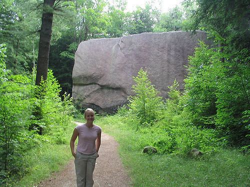
Madison Boulder Natural Area
The town is home to the Madison Boulder (43°55′52″N 71°10′04″W), the largest known glacial erratic in New England, and among the largest in the world. Madison Boulder is a huge granite rock measuring 83 feet (25 m) in length, 23 feet (7.0 m) in height above the ground, and 37 feet (11 m) in width. It weighs upwards of 5,000 tons. A part of this roughly rectangular block is buried, probably to a depth of ten to twelve feet. It is located at a state park in the northwest part of town.