
Time zone MST (UTC+05:00) | Distance to Malé 417 km (259 mi) Area 34 ha | |
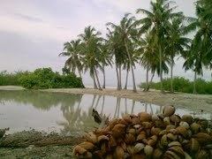 | ||
Madaveli (Dhivehi: މަޑަވެލި) is one of the inhabited islands of Gaafu Dhaalu Atoll. Q1 (island code). Kaadedhdhoo Domestic Airport is situated on a nearby island. Madaveli is the third largest in the atoll in terms of population and is closeted island to the atoll's capital Thinadhoo. Fishing is the main source of income while few resorts and domestic airport nearby provides alternative source of income to the islanders.
Map of Madavelli, Maldives
Secretariat is Mr. Hussain Qasim
Secession of the Suvadive Islands
In January 1959, the three southern atolls: Huvadhu, Fuvahmulah and Addu, were involved in setting up the breakaway United Suvadive Republic which survived in Addu until September 1963. The name of the secessionist state was taken from the ancient name of this atoll.[1] In some islands, like Gaddhoo, there was opposition to the secession, and by means of threats and arson, the groups of people opposing the Suvadive state were forced to agree. The capital of Havaru Thinadhoo was burnt down by soldiers sent by then Prime Minister Ibrahim Nasir from Malé during the secession in 1962, after which it was left uninhabited for four whole years and the atoll served its capital at Gaddhoo more than ten(10)years.