
Country Bolivia Canton Machacamarca Canton Time zone BST (UTC-4) | Department Oruro Department Elevation 12,231 ft (3,728 m) | |
 | ||
Municipality Machacamarca Municipality Province Pantaleón Dalence Province | ||
Machacamarca oruro
Machacamarca is a small town in the Pantaléon Dalence Province in the Oruro Department in Bolivia. It is the seat of the Machacamarca Municipality and of the Machacamarca Canton. At the time of census 2001 it had a population of 2,206. The town is situated south of Oruro near the south-eastern shore of Lake Uru Uru at the road and railway that lead to Poopó.
Contents
Map of Machacamarca, Bolivia
Machacamarca is the hispanicized spelling of Aymara: Machaqa Marka, machaqa = new, marka = village, town: So the name means "new village" or "new town".
The people in the Machacamarca Municipality are mainly Quechua (80.7%).
Places of interest
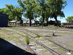
Some of the tourist attractions of Machacamarca are the railway museum, the church in the colonial village of Sora Sora, hot springs, chullpas and ruins.
References
Machacamarca (Oruro) Wikipedia(Text) CC BY-SA