
Country Italy Demonym(s) Macchiani Dialing code (+39) 0737 Population 16 (2001) Province Province of Macerata Patron saint John the Baptist | Region Marche Time zone CET (UTC+1) Elevation 1,078 m Postal code 62039 Dialling code 737 | |
 | ||
Comune Castelsantangelo sul Nera | ||
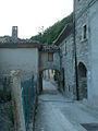
Macchie is an Italian village and hamlet (frazione) of the municipality of Castelsantangelo sul Nera, in the Province of Macerata, Marche. For ISTAT 2001 census, it had a population of 16.
Contents
Map of 62039 Macchie, Province of Macerata, Italy
Geography
The village is placed at 1078 metres in the middle of the Monti Sibillini National Park.
The name "Macchie" derives from the woods (in Italian: macchie) that surround the village. It is a mountainous area in the national park of the Sibillini mountains. Below the village one can admire the Vallinfante valley and nearby the Passo Cattivo, Porche di Vallinfante, Colle La Croce, Monte Pagliano, Monte Prata and Monte Cardosa. The village is also at the foot of Monte Cornaccione which, however, cannot be seen entirely from the village.
Places of interest
There are two churches in Macchie: St. Anthony's (in Italian: Chiesa di Sant'Antonio) and St. John's(in Italian: Chiesa di San Giovanni Battista). At about 100 metres below the village there ia a chapel: The Little Virgin (in Italian: La Madonnella), dedicated to the latter. It was restored and consecrated again in August 2007.
Likewise another chapel, along a nearby mountain: The Virgin of Forcella's Chapel (in Italian: Cappella della Madonna della Forcella), was completely rebuilt in the summer of 2008 by a group of volunteers.