
Constructed 31 October 1998 | Length 5.198 km | |
 | ||
Existed: October 1, 1998 (1998-10-01) – present County | ||
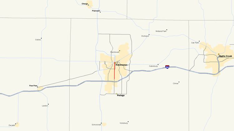
M-331 is an unsigned state trunkline highway in the U.S. state of Michigan located within the city of Kalamazoo. It runs from the southern city limits north into downtown Kalamazoo. This was one of many highways to be established or realigned as a result of a rationalization process initiated in 1998 during the tenure of Governor John Engler. M-331 uses streets in Kalamazoo that were once part of US Highway 131 (US 131) before a freeway was built that bypassed the downtown area.
Contents
Map of M-331, Kalamazoo, MI, USA
Route description
M-331 runs along Westnedge Avenue from the intersection of Kilgore Road on the Kalamazoo–Portage city limit near an exit with Interstate 94 (I-94). It runs north from this endpoint, which is unconnected to the rest of the trunkline system, to the vicinity of Crane Park in Kalamazoo along Westnedge Avenue. M-331 runs west of Blanche Hull Park and east of the Kalamazoo Country Club. It also passes immediately next to the Mt. Ever-Rest Cemetery. From Crane Park northward, Park Street carries the northbound traffic while Westnedge Avenue is restricted to the southbound traffic. Along this pairing of one-way streets, M-331 passes South Westnedge Park and meets Bronson Park at the intersection of Michigan Avenue (eastbound Business Loop Interstate 94/M-43 and northbound Business US Highway 131) downtown. The M-331 designation ends at Michigan Avenue, and Westnedge Avenue and Park Street continue north as Bus. US 131.
History
The current alignment of M-331 was part of the long-time alignment of US 131 before that highway was relocated onto a freeway west of Kalamazoo in the 1960s. The trunkline was designated on October 1, 1998 as part of a rationalization process started by Governor John Engler designed to transfer control of roads and streets in Michigan of economic importance to the state. The highway is not shown on the official state map published by the Michigan Department of Transportation, but it is labeled on the truck operator's map as an "unsigned state highway".
Major intersections
The entire highway is in Kalamazoo, Kalamazoo County.