
Length 1.72 km | Constructed 1960 | |
 | ||
Existed: 1960 – December 9, 2010 | ||
M-108 was a state trunkline highway in the US state of Michigan. The highway followed Nicolet Street, although some maps also labeled it as the Mackinaw Highway. The road was on the boundary between Emmet and Cheboygan counties.
Contents
- Map of Michigan Hwy 108 Mackinaw City MI 49701 USA
- Route description
- History
- Major intersections
- References
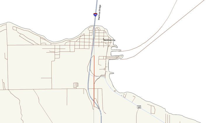
Map of Michigan Hwy 108, Mackinaw City, MI 49701, USA
The original M-108 designation dated back to 1928. This version was transferred to local control in 1957, but revived later under a different routing in 1960. On April 29, 2010, the Petoskey News-Review reported that the Michigan Department of Transportation (MDOT) will rebuild the roadway in preparation to transfer it back to local control once again. MDOT and local officials signed memoranda of understanding, completing the transfer of the roadway on December 9, 2010.
Route description
The 1.069-mile (1.720 km) long route connected two interchanges off Interstate 75 (I-75) on the south side of Mackinaw City with a tourist welcome center. The southern terminus was at a partial interchange with I-75 (exit 337) just south of Mackinaw City on the boundary between Emmet and Cheboygan counties. This interchange is about two miles (3 km) north of the northern terminus of US Highway 31 (US 31). M-108 followed Nicolet Street north from I-75 into the Village of Mackinaw City past the Thunder Falls Water Park and some local motels to an intersection with US 23. North of the US 23 intersection is the Michigan Welcome Center and other tourist amenities on the west side of the street. State maintenance ends at the intersection with the off-ramp from northbound I-75 exit 338.
History
In 1928, the first M-108 designation was commissioned along a rare three-legged route connecting the State Highway Ferry Docks with the Fort Michilimackinac State Historic Park and US 31. At one point while traveling westbound on M-108, motorists could turn right onto northbound M-108 or left onto southbound M-108. In preparation for the opening of the Mackinac Bridge, the Michigan State Highway Department transferred all of M-108 to local control in late 1957, decommissioning the designation at the same time. In 1960, the current M-108 was commissioned along the current routing.
On April 29, 2010, MDOT announced plans to transfer M-108 in its entirety to the Village of Mackinaw City and Emmet County. In preparation for this transfer, MDOT repaved, widened and reconstructed the roadway. While rebuilding the section of the highway between US 23 and the northern terminus, the Welcome Center was closed. Plans had this section to be completed, and the center to bed reopened, for Memorial Day weekend, with the remainder of construction to be completed in August. Following the transfer to local control, M-108 ceased to be a state highway and the designation was decommissioned. Previous news reports stated that the roadway was too small to merit highway status under federal guidelines. The transfer was completed on December 9, 2010 when MDOT and local officials signed memoranda of understanding to affect the transfer. The section within the Village of Mackinaw City was transferred to the village, and the remainder to Emmet County.
Major intersections
The entire highway was on the Emmet–Cheboygan county line.