
Country Vietnam Capital Mù Cang Chải Area 1,199 km² Population 42,574 (2003) | Region Northeast Time zone UTC + 7 (UTC+7) Province Yen Bai Province Local time Friday 12:45 AM | |
 | ||
Mù Cang Chải is a rural district of Yên Bái Province, in the Northeast region of Vietnam. As of 2003, the district had a population of 42,574. The district covers an area of 1,199 km². The district capital lies at Mù Cang Chải.
Map of M%C3%B9 Cang Ch%E1%BA%A3i District, Y%C3%AAn B%C3%A1i, Vietnam
Mu Cang Chai is a district of Yen Bai province. It shares the border in the north with Van Ban district of Lao Cai province, neighboring in the south of Muong La district of Son La province, being the west of Than Uyen Lai Chau province, sharing in the east of Van Chan district and Yen Bai province. The district is located at the foot of Hoang Lien Son mountain range, at an altitude of 1,000 metres above sea level. To get to Mu Cang Chai district, travellers must pass through Khau Pha Pass, which is one of four imposing passes in the northwest of Vietnam.
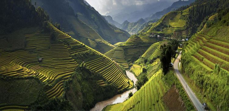
The rice terrace fields in La Pan Tan, Che Cu Nha and Ze Xu Phinh have been recognized as national landscapes by the Ministry of Culture, Sports and Tourism. There have been local festivals in Yen Bai and the Mu Cang Chai rice terrace fields have been used to attract both domestic and international tourists. This region of northwest Vietnam is poor and relatively undeveloped but is very rich in natural beauty. In the recently years, Mu Cang Chai has been a popular place to visit in the north of Vietnam, particularly when the rice harvest starts around the beginning of October.
The Mu Cang Chai Rice Terrace Fields stretch across 2,200 hectares of the mountainside as narrow layers of terraces ranging from between 1m and 1.5m wide. Around 500 hectares of these terraces belong to 3 communes such as La Pan Tan, Che Cu Nha and Ze Xu Phinh.
Mu Cang Chai Rice Terrace has been recognized as one of the unique landscapes of Vietnam, it was at the highest ranked national landscape in 2007. One issue faced by the local people was keeping the water sources on the land and ground for growing rice on the slope of mountain. The Hmong people developed a way to retain water by making the levelling the land on the mountain to create the rice terrace fields.
Mu Cang Chai Tours The water source of the fields comes from the upper streams and waterfalls. When there are low points in the mountain it is important to overcome this by moving water from higher places. Bamboo is cut in half and used as a tool to transfer water using natural gravity into the fields, according to Hmong People’s experience of working on it, the water is moved into the first terrace then a gate is opened to make the water flow into the next terrace using a gate. This process avoids flooding the fields and retains the soil fertility. To create the contour of each piece of land, the Hmong people balance each terrace by water that people will point out a high place that is moved up on the coast and moved down to the low land so the fields surrounding hills are water level and the same height, creating the beautiful rice terraces of the mountain.