
Prominence 768 m (2,520 ft) Elevation 1,323 m | Isolation 54 km (34 mi) Easiest route paved road | |
 | ||
Similar Smrk, Radhošť, Praděd, Javorový vrch, Kněhyně | ||
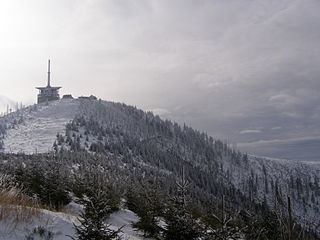
Lysá hora ( [ˈlɪsaː ˈɦora]; Polish: Łysa Góra; German: Lysa-berg, Kahlberg, local Silesian: Gigula) is the highest mountain of the Moravian-Silesian Beskids range in the Czech Republic and also of Cieszyn Silesia. It is one of the rainiest places of the country with an annual precipitation of over 1,500 mm (60 in). It is the 26th highest mountain in Czech.
Contents
Map of Lys%C3%A1 hora, 739 04 Kr%C3%A1sn%C3%A1, Czechia
Lys hora drone
EtymologyEdit
The name Lysá hora can be translated as bald mountain. This name came from the fact that Lysá hora had no trees. The place is first mentioned in a written document from 1261 as Lissa huera.
TourismEdit
Today, the mountain is also a small ski resort and a popular place for hiking in summer.
Nowadays, this summit is getting popular. Every day there are hundreds to thousands of casual hikers and funs of Nordic-walking, running, cross-country skiing and skialpinismus.
This place is a witness of many interesting sport contest, noteworthy is "Lysá Hora 24" (LH24), (LH365), "Beskydian Seven" (B7), Adrenalin Cup, "Five of Beskydian Summits"(5BV) and "Lysá Cup" (LC).