
- right Koorabooka Creek - elevation 535 m (1,755 ft) - elevation 137 m (449 ft) Source Teano range | - location below Staten Hill - location Jimba Jimba Length 561 km | |
 | ||
- left Calbrajacka Creek, Onslow Creek, Edmund River, Frederick River | ||
Lyons river run 2013
The Lyons River is a river in the Gascoyne region of Western Australia.
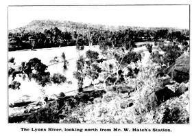
The headwaters of the Lyons rise just west of the Teano Range and the river flows generally south-west, joined by 36 tributaries including the Edmund River, Frederick River, Onslow Creek, Gifford Creek, Koorabooka Creek and Ulura Creek. The Lyons reaches its confluence with the Gascoyne River near the township of Gascoyne Junction near the southern end of the Kennedy Range. The river descends 398 metres (1,306 ft) over its 561-kilometre (349 mi) course.
Several permanent pools of water exist along the river including Cattle Pool, Windarrie Pool and Bubbawonnara Pool.
The Lyons River is known as Mithering by the local Indigenous Australians, the Malgaru people. The first European to discover the river was explorer Francis Gregory in 1858, he named the river after the naval hero Admiral Sir Edmund Lyons.