
Country Philippines District 1st district Time zone PST (UTC+8) Local time Wednesday 12:52 PM | Region Bicol (Region V) Barangays Area 199.1 km² Province Camarines Sur | |
 | ||
Founded 1726 (as a distinct municipality) Weather 27°C, Wind NE at 18 km/h, 74% Humidity | ||
State of barangay address bel cruz lupi camarines sur
Lupi is a third class municipality in the province of Camarines Sur, Philippines. According to the 2015 census, it has a population of 32,167 people.
Contents
- State of barangay address bel cruz lupi camarines sur
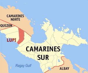
- Map of Lupi Camarines Sur Philippines
- History
- Barangays
- Demographics
- References
Map of Lupi, Camarines Sur, Philippines
History
Lupi, in the first district of the province, was branded as a "travelling poblacion" as it had been transferred several times when it was a small settlement during Spanish rule. On 17 October 1726, however, the Spanish government under the administration of Governor General Marquéz de Torrecampo who was also the titular head of the Diocese of Caceres, issued a decree making Lupi a separate town.
Barangays
Lupi is politically subdivided into 38 barangays.
Demographics
In the 2015 census, the population of Lupi, Camarines Sur, was 32,167 people, with a density of 160 inhabitants per square kilometre or 410 inhabitants per square mile.