
OS grid reference SD837248 Post town ROSSENDALE Dialling code 01706 | Sovereign state United Kingdom Postcode district BB4 District Rossendale | |
 | ||
Lumb is a small village in the Rossendale district of Lancashire, England. It lies in the valley of the River Whitewell, 3 miles (5 km) north east of Rawtenstall. It should not be confused with the hamlet of Lumb near Edenfield, also in the Rossendale district.
Map of Lumb, Rossendale, UK
Lumb was historically in the large ancient parish of Whalley. In 1846 it was constituted a chapelry within the parish of Whalley, which also included the village of Water. In 1866 it became part of the civil parish of Newchurch, and in 1894 was transferred to the municipal borough and civil parish of Rawtenstall.
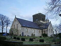
St Michael's parish church was founded in 1846.
References
Lumb, Rawtenstall Wikipedia(Text) CC BY-SA