Country United States County Monterey County GNIS feature ID 1660963 Zip code 93920 | State California FIPS code 06-44427 Elevation 108 m Local time Tuesday 6:17 AM | |
 | ||
Weather 13°C, Wind SE at 3 km/h, 83% Humidity | ||
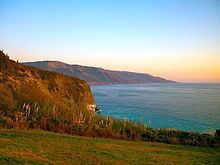
Lucia is an unincorporated community in Monterey County, California. It is located 1 mile (1.6 km) east of Lopez Point, at an elevation of 354 feet (108 m). Lucia is one of the three small settlements of restaurants, and motels located along State Route 1 on the Big Sur coast. The ZIP Code is 93920, but mail sent to Lucia must be addressed "Big Sur". The community is inside area code 831.
Contents
Map of Lucia, CA 93920, USA
A post office operated at Lucia from 1900 to 1933, moving in 1906, and from 1936 to 1938. The name honors Lucia Dani, its first postmaster. The movie Zandy's Bride is loosely based on the Harlan clan that still operates the facilities.
Government
At the county level, Lucia is represented on the Monterey County Board of Supervisors by Supervisor Dave Potter.
In the California State Legislature, Lucia is in the 17th Senate District, represented by Democrat Bill Monning, and in the 30th Assembly District, represented by Democrat Anna Caballero.
In the United States House of Representatives, Lucia is in California's 20th congressional district, represented by Democrat Jimmy Panetta
