
Country Philippines Established 1905 Time zone PST (UTC+8) Population 9,369 (2010) Province Kalinga | District Lone District Barangays Area 234.2 km² Local time Tuesday 7:28 PM Dialling code 74 | |
 | ||
Region Cordillera Administrative Region (CAR) Weather 22°C, Wind NE at 3 km/h, 93% Humidity | ||
Lubuagan is a fourth-class municipality in the province of Kalinga, Philippines. According to the 2010 census, it has a population of 9,369 people. It is 460 kilometres (290 mi) north of Manila and 50 kilometres (31 mi) from Tabuk.
Contents
Map of Lubuagan, Kalinga, Philippines
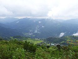
Lubuagan Municipality, once the seat of the National Government from March 6 to May 17, 1900, during the time of Gen. Emilio Aguinaldo, was among the eight (8) municipalities of the new province of Kalinga. It is located at 800 metres (2,600 ft) above sea level in the southern part of Kalinga and in the heart of the Cordillera. It has a land area of 23,420 hectares (57,900 acres). Some of its younger generation have migrated either in the lowland plains of Tabuk or in other provinces in search for income and employment opportunities.
Barangays
Lubbuagan municipality has 9 barangays, as listed below with the 2010 census population shown in brackets.
History
Spanish Rule was never established in Lubuagan during the more than 300 years of sovereignty over the Philippines. However, President Emilio Aguinaldo, president of the erstwhile first Republic of the Philippines made Lubuagan the Capital of that first Republic for 72 days, from March 6 to May 17, 1900, before his escape and eventual capture at Palanan, Isabela, on March 23, 1901.
Upon the assumption of the United States of America as colonial power over the Philippines, the Township of Lubuagan, a unit of government at the time it was established in 1905 which was administered via the sub provincial government of Lepanto-Bontoc sub-province, Lt. Governor E. A. Eckman, an American ex-soldier was the Chief Executive of the sub-province.
Sometimes in 1907, Kalinga was separated and organized as a distinct sub-province from the Lepanto-Bontoc sub-province. Franklin Walter Hale was appointed the first Lt. Governor to establish a civil government in Kalinga.
Bulanao Barrio, a thriving big community of Tubog at the time, the site of which is the present homestead of Mr. Abe Umao was the target of Lt. Governor Hale as the center of this Administration of government in Kalinga sub-province. But shortly thereafter, the great cholera and malaria epidemic broke out in the later part of 1907 and continued in 1908 which almost wiped out the town populace. Lt. Governor Hales was himself attacked with malaria so that he and his official family were forced to leave Bulanao because those who survived the epidemic among the natives left.
Lt. Governor Hale and his staff came up to Lubuagan in the early part of 1909 and established their quarters and camps where the present multi-purpose Hall now stands. Governor Hale whom the people baptized and fondly called SAPAO, first organized his police contingent from and among the tribal pangats and headmen from the different villages of Kalinga to help them tame the natives who are still afraid and suspicious of the new order.
Lt. Governor Hale served Kalinga up to the end of July 1915. He was replaced by Lt. Governor Samuel Kane, who served for a brief period and wasreplaced by Lt. Gov. Alex Gilfilan in September 1916, who was later on replaced by what is now nomenclatured as Deputy Governor Mr. Thomas Blanco, a Filipino. In 1924, Deputy Governor Nicasio Balinag took over the reign of Sub-Provincial Executive of Kalinga.
The colonial Civil Government notably beginning with the administration of Lt. Governor Franklin Walter Hale up to the Commonwealth government is considered the golden years of Lubuagan, the capital town of the sub-province of Kalinga. Lubuagan at that time was the center of education, culture, commerce and trade. The founding of the Kalinga Academy in 1927, a secondary school run by American Missionaries and the St. Teresita's School in 1929, a Catholic Primary and High School managed by the CICM Belgian Missionaries bolstered the luster of Lubuagan.
The Japanese Imperial army occupation came to Lubuagan in May 1942.
In 1945 during the war of liberation, Lubuagan was bombed by American planes resulting in the destruction of the Lubuagan Central School which was then occupied by the enemy. The big and beautiful St. Peter's church of Lubuagan which resembles the Saint Peter's Basicila of Rome with its high dome, the father's convent and two more buildings within the compound were all burned to the ground. Lubuagan was once the capital of Kalinga sub-province before Tabuk rose to its present status as the center of learning and government activities. It is also in Lubuagan where the first instruction of higher learning (College) in the old Mt. Province was established.
(Source: Souvenir Book: Kalinga 7th Foundation Day)
Attractions
Festival
Sallidumay Festival – Lubuagan's municipal festival focusing on the tribal music, dances and rituals of the tribe.