
- land 21.2 sq mi (55 km) Local time Tuesday 2:56 AM | - summer (DST) EDT (UTC-4) | |
 | ||
- water 0.1 sq mi (0 km), 0.47% Weather -3°C, Wind NE at 13 km/h, 93% Humidity | ||
Lower Towamensing Township is a township in Carbon County, Pennsylvania, United States. The Delaware Peoples name is eponymous and was once applied by the natives to the whole region of Carbon County and bits of the Poconos to the north (Luzerne County) and to Schuylkill County (southwest). The population was 3,228 at the 2010 census.
Contents
- Map of Lower Towamensing Township PA USA
- History
- Geography
- Neighboring municipalities
- Demographics
- Notable residents
- References
Map of Lower Towamensing Township, PA, USA
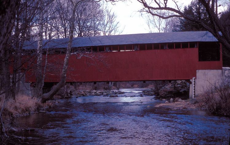
History
The Aquashicola Volunteer Fire Department has provided service in the township for many years. The Little Gap Covered Bridge was added to the National Register of Historic Places in 1980.
Geography
The township is in southeastern Carbon County and is bordered by Northampton County to the south and Monroe County to the east. According to the United States Census Bureau, the township has a total area of 21.30 square miles (55.17 km2), of which 21.25 square miles (55.05 km2) is land and 0.05 square miles (0.12 km2), or 0.21%, is water. It is drained by tributaries (Aquashicola Creek, etc.) of the Lehigh River which separates it from East Penn Township, and its southern geographic boundary is Blue Mountain.
Villages in the township include Aquashicola (locally pronounced "ack-wa-SHIK-la"), Christian Corner, Hazard, and Little Gap (which hosts the Blue Mountain Ski Area). Pennsylvania Route 248 passes through the westernmost parts of the township, following the Lehigh River, and connects Lehighton to the northwest with the Allentown–Bethlehem area to south, as well as having nearby interchanges in Palmerton and Bowmanstown.
Neighboring municipalities
Demographics
As of the census of 2000, there were 3,173 people, 1,207 households, and 900 families residing in the township. The population density was 150.4 people per square mile (58.1/km²). There were 1,296 housing units at an average density of 61.4/sq mi (23.7/km²). The racial makeup of the township was 98.74% White, 0.13% Native American, 0.06% Asian, 0.44% from other races, and 0.63% from two or more races. Hispanic or Latino of any race were 1.04% of the population.
There were 1,207 households out of which 31.0% had children under the age of 18 living with them, 64.0% were married couples living together, 7.0% had a female householder with no husband present, and 25.4% were non-families. 19.2% of all households were made up of individuals and 8.7% had someone living alone who was 65 years of age or older. The average household size was 2.61 and the average family size was 2.99.
In the township the population was spread out with 22.9% under the age of 18, 7.5% from 18 to 24, 31.1% from 25 to 44, 24.5% from 45 to 64, and 14.0% who were 65 years of age or older. The median age was 39 years. For every 100 females there were 100.3 males. For every 100 females age 18 and over, there were 100.2 males.
The median income for a household in the township was $36,414, and the median income for a family was $40,855. Males had a median income of $32,113 versus $23,654 for females. The per capita income for the township was $16,878. About 6.5% of families and 8.3% of the population were below the poverty line, including 13.0% of those under age 18 and 5.9% of those age 65 or over.