
Country United States Settled 1717 Time zone Eastern (EST) (UTC-5) Population 8,268 (2010) Area code 717 | County Dauphin Incorporated 1961 Website www.lowerswatara.org Local time Tuesday 2:53 AM University Penn State Harrisburg | |
 | ||
Weather -3°C, Wind NE at 16 km/h, 91% Humidity | ||
Lower Swatara Township is a township in Dauphin County, Pennsylvania, United States. The population was 8,268 at the 2010 census. Harrisburg International Airport and Penn State Harrisburg are located within the township.
Contents
Map of Lower Swatara Township, PA, USA
History
Lower Swatara Township is bordered by the Susquehanna River on the south and Swatara Creek to the east. The township name is derived from a Native American language. The word is thought to be from an Iroquois word meaning "Where we fed on eels." The Natives established a network of pathways through the area. Presbyterian settlers from Scotland and Ireland were followed by settlers from the German Palatinate. The first settlers erected their log homes along the banks of the Susquehanna and Swatara.
The population in Pennsylvania increased. In 1729 Paxtang Township of Lancaster County was established. The spelling "Paxtang" is from the original Native name Peshtank, which meant "standing water".
On March 4, 1785, Dauphin County was formed from Lancaster County, named for the Dauphin of France, heir apparent to the French throne, whose country the area government wanted to honor for its assistance in the Revolutionary War. In August 1787 the legislature separated Paxtang Township into Upper Paxtang, Middle Paxtang and Lower Paxtang townships.
Lower Paxtang Township embraced the areas now occupied by Lower Swatara, Swatara, Lower Paxton, Derry and Susquehanna townships.
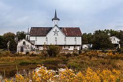
Lower Swatara Township was incorporated from Swatara Township on November 7, 1961, as a first class township. Within Lower Swatara are the Conrad and Margaret Allerman House and the Star Barn Complex, both listed on the National Register of Historic Places.
Geography
Lower Swatara Township is in southern Dauphin County, bordered by York County to the southwest across the Susquehanna River, by the boroughs of Highspire and Steelton to the west, by Swatara Township to the northwest and north, Derry Township to the northeast across Swatara Creek, and Londonderry Township and the borough of Middletown to the southeast. Unincorporated communities in Lower Swatara Township include Ebenezer in the north, Freys Grove in the east along Swatara Creek, Greenwood Hills near the center, and Meade Heights and Jednota in the south. Harrisburg International Airport occupies the southernmost land in the township, along the Susquehanna River.
According to the United States Census Bureau, the township has a total area of 14.8 square miles (38.3 km2), of which 12.3 square miles (31.9 km2) is land and 2.5 square miles (6.4 km2), or 16.79%, is water. Most of the water area is in the Susquehanna River.
Demographics
As of the census of 2000, there were 8,149 people, 3,003 households, and 2,201 families residing in the township. The population density was 672.3 people per square mile (259.6/km²). There were 3,124 housing units at an average density of 257.7/sq mi (99.5/km²). The racial makeup of the township was 93.70% White, 3.07% African American, 0.05% Native American, 1.53% Asian, 0.01% Pacific Islander, 0.58% from other races, and 1.06% from two or more races. Hispanic or Latino of any race were 1.91% of the population.
There were 3,003 households, out of which 33.1% had children under the age of 18 living with them, 60.3% were married couples living together, 9.7% had a female householder with no husband present, and 26.7% were non-families. 22.4% of all households were made up of individuals, and 6.8% had someone living alone who was 65 years of age or older. The average household size was 2.52 and the average family size was 2.94.
In the township the population was spread out, with 23.4% under the age of 18, 9.8% from 18 to 24, 28.9% from 25 to 44, 25.4% from 45 to 64, and 12.5% who were 65 years of age or older. The median age was 38 years. For every 100 females there were 95.9 males. For every 100 females age 18 and over, there were 90.7 males.
The median income for a household in the township was $48,940, and the median income for a family was $58,203. Males had a median income of $39,980 versus $29,436 for females. The per capita income for the township was $23,271. About 3.0% of families and 5.1% of the population were below the poverty line, including 6.9% of those under age 18 and 3.5% of those age 65 or over.
Economy
The US Airways subsidiary Allegheny Airlines had its headquarters on the grounds of Harrisburg International Airport in the township.