
Population 1,869 (2011) Civil parish Lower Holker Dialling code 01539 | OS grid reference SD3677 Sovereign state United Kingdom | |
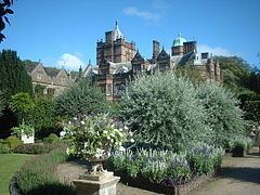 | ||
Lower Holker is a civil parish and electoral ward (called Holker) in the South Lakeland district of the English county of Cumbria. It includes the villages of Cark and Flookburgh, the hamlets of Holker, Ravenstown and Sand Gate, and historic Holker Hall. The parish has a population of 1,808, increasing to 1,869 at the 2011 Census
Map of Lower Holker, UK
In chronostratigraphy, the British sub-stage of the Carboniferous period, the 'Holkerian' derives its name from Holker Hall.
References
Lower Holker Wikipedia(Text) CC BY-SA