
Area 23 ha (57 acres) State Tasmania Elevation 82 m | Adjacent bodies of water Southern Ocean Highest elevation 80 m (260 ft) Region South West Archipelago Maatsuyker Islands | |
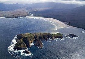 | ||
Louisa Island is an island with a short sandy tombolo, located adjacent to the south-western coast of Tasmania, Australia. The irregularly shaped 23-hectare (0.089 sq mi) island is part of the Maatsuyker Islands Group, and comprises part of the Southwest National Park and the Tasmanian Wilderness World Heritage Site.
Contents
Map of Louisa Island, Tasmania, Australia
The island's highest point is 80 metres (260 ft) above sea level and, at low tide, the island is joined to the mainland by a 250 metres (820 ft) sand spit.
Flora and fauna
The central parts of the island are lightly forested with Eucalyptus nitida and Eucalyptus ovata, with an understorey of Leptospermum scoparium and Melaleuca squarrosa. Bracken covers areas subjected to recent fires.
The island is part of the Maatsuyker Island Group Important Bird Area, identified as such by BirdLife International because of its importance as a breeding site for seabirds. Recorded breeding seabird and wader species are the little penguin, short-tailed shearwater (206,000 pairs), fairy prion (400 pairs), common diving-petrel (1600 pairs), Pacific gull, sooty oystercatcher and pied oystercatcher. Mammals present include the Tasmanian pademelon and long-nosed potoroo. The Tasmanian tree skink is present.