
Population 256 (2011) Civil parish Lorton Local time Monday 5:07 AM | OS grid reference NY1602623548 | |
 | ||
Weather 4°C, Wind SW at 11 km/h, 86% Humidity Points of interest Whinlatter Pass, Go Ape Whinlatter, Whinlatter, Broom Fell, Graystones | ||
Lorton is a village in the district of Allerdale, in the English county of Cumbria. Lorton is made up of two small villages – Low Lorton and High Lorton, both of which are nestled at the northern end of the Vale of Lorton surrounded by the mountains such as Grasmoor, Hopegill Head and Whiteside. The village is approximately 4 miles away from Cockermouth, which offers access to the A66 road. Other nearby settlements include Loweswater and Brigham.
Contents
Map of Lorton, UK
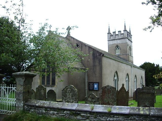
Lorton is relatively untouched by tourism, although many tourists pass through on the way to the Buttermere valley. Nevertheless there are a number of hill walks available from Lorton, for instance Hopegill Head can be climbed from High Lorton and Fellbarrow can be climbed from Low Lorton. Tourists are also encouraged to visit the 12th century St. Cuthbert's Church and the 1663 pele tower, which is, however, not open to public. Lorton's Yew Tree remains the village's only tourist attraction.
The Whinlatter Pass road connects Lorton with Braithwaite, and the main road passing through Lorton links Cockermouth with Buttermere and Loweswater.
The Village
The village consists of 114 households in total with a total area of 5,501 acres Lorton also has a small primary school, a church (St. Cuthbert's 12th century Church), a post office and a tennis club. An award winning public house "The Wheatsheaf Inn" is also present at the village, with the owners having run the inn for more than 10 years. It has achieved notable awards in Food Safety. The village also had a town in Fairfax County, Virginia, USA, named after it.
Etymology
Of the word 'Lorton', " the 2nd el[ement] is clearly OE 'tūn' 'farmstead, village'. The 1st is enigmatic, but Ekwall's suggestion in 'DEPN' of a river name ON 'Hlóra' 'roaring', paralleled in the Norw[ergian] 'Lora', is attractive. " The roaring could refer either to the Whit Beck or the River Cocker, Cumbria. (OE=Old English; ON=Old Norse).
Population
At the 2001 census, Lorton had a population of 250 people, 114 of which were males and 136 females. The population is dominated by two age groups – 45–64 (71 Persons) and 25–44 (61 Persons). Mean age of population in the area is 44.72 years. These figures changed only slightly at the 2011 Census.
Lorton is a fairly isolated village as the residents have to travel on average 27.73 km to workplace with 102 people out of 250 aged 16–74 are economically active whilst only 6 are unemployed.
According to 2001 census the population of the whole Allerdale district is 93,492, making Lorton just under 0.3% of the total population. See Allerdale entry for 2011 statistics.
History
In 1811, Lorton was at the peak of prosperity and population due to high demand on agricultural products as England was recovering from the Napoleonic Wars (1803–1815). The majority of residents were employed in agricultural sector across the 6 farms that were present, including a 17th-century farm called "New House". The farms used to be powered by the fast flowing tributaries of the river Cocker which runs through the whole length of the valley. Furthermore, most of houses and cottages in Lorton started off as barns and mills. St. Cuthbert's records indicate a post-war depression from 1816–1830 as the population decreased by around 50 people and the number of marriages also decreased form 65 to 43.
Jennings Brewery also originates from Lorton. It was set up in 1828 by John Jennings and brewed in Lorton exclusively until 1874.
Lorton Park is a Grade II Listed Regency House; in the 19th century by Richard Harbord, a Liverpool shipping magnate who is buried in the parish church. In 1863, Prince Arthur visited Lorton Park and planted a commemorative chestnut tree in the gardens.
Historical Mentions
Lorton was first mentioned in the Imperial Gazetteer of England and Wales (1870–72) by John Marius Wilson, who described Lorton as "a village, a township, and a parish in Cockermouth district, Cumberland". Wilson also gave some early key statistics such as the value of real property (£3,288), headcount (456) and area (5,264 acres). Lorton was also mentioned some 15 years later in the Gazetteer of the British Isles (1887) by John Bartholomew. Bartholomew also recorded some statistics for the village from which some changes were made apparent – population decreased by 59 to 397 and the area increased by 54 acres to 5318 acres. Furthermore, William Wordsworth, the famous poet born in Cockermouth, immortalised the Lorton Yew Tree in his poem "Yew Trees" in 1804. The tree is calculated to be at least 1000 years old but was severely damaged by a storm shortly after the poem was written.