
 | ||
Lorrimore Square is a square in Southwark, south London, England.
Map of Lorrimore Square, London SE17 3QT, UK
A 1681 map of Walworth made for Dean and Chapter of Canterbury Cathedral shows a common called "Lattam-more" (or Lower Moor), which is now the location for Lorrimore Square.
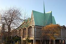
St Paul's Church is located in the centre of the square. Lorrimore Square was hit by incendiary bombs during World War II in 1940 and the original church burned down leaving only the steeple. The current church was built in 1959–60, designed by the architectural practice Woodroffe Buchanan & Coulter, and is Grade II listed. The Lorrimore Drop-in Centre is in the same building as the church on the ground floor. The church and church hall are (unusually) on the first floor.
The church and centre are housed in a reinforced concrete building, with a steep folded plate timber roof, which is covered in green copper. The external walls are brick, reclaimed stone from the original church, and artificial blocks, some with stained glass.
The square is within the SE17 postcode district. The nearest tube station is Kennington to the northwest.
The eastern side of Lorrimore Square falls within a Conservation Area, specifically the Sutherland Square Conservation Area. Southwark Council, the local council, regulates any planning and development that can take place in this area.
Along with Lorrimore Road, Carter Street, Fleming Cottages, Churchwarden House, Greig Terrace and Forsyth Gardens, Lorrimore Square is covered by the local Surrey Gardens Tenant's and Resident's Association who, as leaseholders, hold responsibility for the park in Lorrimore Square.