
Population 118,648 (Jan 2016) | ||
 | ||
Weather 19°C, Wind SW at 8 km/h, 86% Humidity Points of interest Window on China Theme P, Taoyuan Hakka Culture H, Longtan Lake, Sankeng Street, Shimenshan Hiking Trail | ||
Longtan District (Chinese: 龍潭區; pinyin: Lóngtán Qū) is a rural district in southern Taoyuan City, Taiwan. Longtan is home to the headquarters of the Republic of China Army.
Contents
- Map of Longtan District Taoyuan City Taiwan 325
- History
- Geography
- Administrative divisions
- Government institutes
- Education
- Tourist attractions
- Transportation
- References
Map of Longtan District, Taoyuan City, Taiwan 325
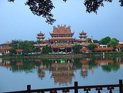
The township is known for the Buddhist temple in the center of Longtan Lake and the large Bainien community project. The area is surrounded by high-tech industries and mountains.
Longtan is home to a number of military bases, and a few research installations. National Chung-Shan Institute of Science and Technology and Institute of Nuclear Energy Research are two of the more well known ones.
History
Longtan used to be a rural township of the former Taoyuan County. On 25 December 2014, it was upgraded into a district of Taoyuan City.
Geography
Administrative divisions
Huangtang, Yongxing, Zhongshan, Wushulin, Wulin, Bonian, Lingyun, Longxiang, Bade, Shengde, Shanglin, Longtan, Longxing, Zhongzheng, Shanghua, Jiulong, Wuhan, Tungxing, Zhongxing, Beixing, Jiaan, Sankeng, Daping, Sanlin, Jianlin, Fulin, Gaoping, Gaoyuan, Sanhe and Sanshui Village.
Government institutes
Education
Tourist attractions
Transportation
Longtan is served by National Highway No. 3.