
Topo map OS Landranger 183 Prominence 171 m Listing Marilyn | OS grid ST786376 Elevation 288 m Parent peak Black Down, Somerset | |
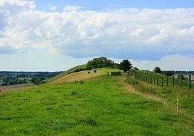 | ||
Long Knoll (grid reference ST794376) is a 34.2 hectare biological Site of Special Scientific Interest in the west of the English county of Wiltshire, notified in 1971.
Long Knoll is a ridge of chalk grassland some 1.5 km long. It forms the parish boundary between Kilmington to the south and Maiden Bradley to the north.
The ridge is 288m above sea level at its highest point. It is possible to view King Alfred's Tower, Cranmore Tower, the Black Mountains and Glastonbury Tor on clear days. Long Knoll is a Marilyn.
References
Long Knoll Wikipedia(Text) CC BY-SA