
 | ||
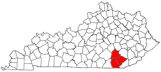
The London, Kentucky micropolitan area is made up of three counties in the Eastern Coalfield region of Kentucky. Before 2013, the area was officially known as the Corbin-London, KY Combined Statistical Area, and consisted of the Corbin Micropolitan Statistical Area and the London Micropolitan Statistical Area. The Corbin micropolitan area consisted of Whitley County, and the London micropolitan area consisted of Laurel County.
Contents
- Counties
- Incorporated places
- Census designated places
- Knox County
- Laurel County
- Whitley County
- Demographics
- References
In 2013, the United States Census Bureau folded the CSA into the redefined London micropolitan area, and Knox County was added to the statistical area. This incidentally ended a statistical anomaly that excluded the 20% of the population of Corbin living in Knox County from the statistical area.
As of the 2010 United States Census, the region now defined as the London micropolitan area had a population of 126,369.
As of the census of 2000, the statistical area, which then consisted of only Laurel and Whitley Counties, had a population of 88,580 and had an estimated population of 96,562 in 2009.
Counties
Incorporated places
Census-designated places
Note: All census-designated places are unincorporated.
Knox County
Laurel County
Whitley County
Knox County
Laurel County
Whitley County
Demographics
As of the census of 2000, there were 88,580 people, 34,163 households, and 25,414 families residing within the CSA. The racial makeup of the CSA was 97.66% White, 0.6% African American, 0.2% Native American, 0.3% Asian, 0.002% Pacific Islander, 0.2% from other races, and 1.0% from two or more races. Hispanics or Latinos of any race were 1.1% of the population.
The median income for a household in the CSA was $25,254, and the median income for a family was $30,193. Males had a median income of $21,507 versus $15,031 for females. The per capita income for the CSA was $13,603.