
Time zone CET (UTC+1) Area 59.4 km² Province Province of Florence Dialling code 055 | Demonym(s) Londesi Elevation 226 m Local time Sunday 10:59 AM Postal code 50060 | |
 | ||
Frazioni Caiano, Fornace, Rincine, Rata, Vierle, Petroio, Bucigna, Sambucheta, San Leolino. Weather 11°C, Wind W at 2 km/h, 37% Humidity | ||
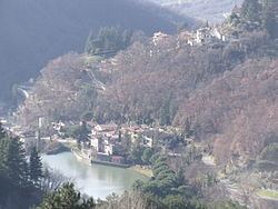
Londa is a municipality in the Province of Florence in the central Italian region Tuscany.
Contents
Map of 50060 Londa, Florence, Italy
Geography
The neighbouring communes are Dicomano, Pratovecchio, Rufina, San Godenzo and Stia.
The toponym is first recorded in a document of 1028 as Unda, meaning "wave" and alluding to the torrent on which it is situated. The wave appears in the communal coat of arms.
References
Londa, Tuscany Wikipedia(Text) CC BY-SA