
Opening date April 1937 Opened April 1837 Construction began 1933 | Creates Pool 7 Catchment area 161,460 km² Impound Upper Mississippi River | |
 | ||
Location Campbell, La Crosse County, Wisconsin / Dresbach Township, Winona County, Minnesota,
near La Crescent, Minnesota, USA Impounds Upper Mississippi River Length 940 feet (286.5 m) (movable portion) Total capacity 105,000 acre·ft (0.130 km) Operator United States Army Corps of Engineers Similar Lock and Dam No 6, Lock and Dam No 8, Lock and Dam No 5A, Lock and Dam No 5, Lock and Dam No 3 | ||
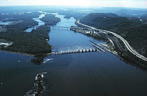
Lock and Dam No. 7 is a lock and dam located near Onalaska, Wisconsin on the Upper Mississippi River. It forms pool 7 and Lake Onalaska.
Map of Lock and Dam No. 7, Campbell, WI 54603, USA
The facility is located on Mississippi River mile 702.5 near La Crescent, Minnesota. It was constructed and placed in operation in April, 1937 and underwent major rehabilitation from 1989 through 2002.
The entire system consists of a concrete structure 940 feet (286.5 m) long with five roller gates and 11 tainter gates, a segment of earth embankment 8,100 feet (2,468.9 m) long from the dam to French Island separated by a concrete spillway 1,000 feet (304.8 m) long, and another embankment 2,400 feet (731.5 m) long from French Island to Onalaska which has a concrete spillway 670 feet (204.2 m) long. The lock is 110 feet (33.5 m) wide by 600 feet (182.9 m) long.