
Opening date March 12, 1940 Creates Pool 24 Area 42 ha Construction began July 1936 | Length 1,340 feet (408.4 m) Opened 12 March 1940 Added to NRHP 10 March 2004 Impound Upper Mississippi River | |
 | ||
Location Belleview Precinct, Calhoun County, Illinois / Clarksville, Missouri, USA Impounds Upper Mississippi River Total capacity 125,363 acre·ft (0.154633 km) Operator United States Army Corps of Engineers Similar Lock and Dam No 22, Lock and Dam No 20, Lock and Dam No 16, Lock and Dam No 18, Lock and Dam No 19 | ||
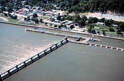
Lock and Dam No. 24 is a lock and dam located near Clarksville, Missouri around river mile 273.4 on the Upper Mississippi River. The main lock is 110 feet (33.5 m) wide and 600 feet (182.9 m) long with its bottom at an elevation of 430 feet. The auxiliary lock is not operational. Normal pool elevation behind the dam is 449 feet. The movable portion of the dam is 1,340 feet (408.4 m) long and consists of 15 submersible, elliptical, tainter gates. A 2,720 feet (829.1 m) submersible earthen dike extends from the movable dam to the Illinois shore. In 2004, the facility was listed in the National Register of Historic Places as Lock and Dam No. 24 Historic District, #04000183 covering 1,027 acres (4.2 km2), 3 buildings, 15 structures, 4 objects.
Map of Lock and Dam No. 24, Clarksville, MO 63336, USA
References
Lock and Dam No. 24 Wikipedia(Text) CC BY-SA