
Opening date July 22, 1938 Opened 22 July 1938 Catchment area 356,124 km² Construction began 1934 | Creates Pool 22 Area 51 ha Added to NRHP 10 March 2004 | |
 | ||
Location Cincinnati Township, Pike County, Illinois / Saverton Township, Ralls County, Missouri,
near Saverton, Missouri Impounds Upper Mississippi River Length 1,224 feet (373.1 m) (movable portion) Total capacity 80,000 acre·ft (0.099 km) Operator United States Army Corps of Engineers Similar Lock and Dam No 20, Lock and Dam No 24, Lock and Dam No 18, Lock and Dam No 16, Lock and Dam No 19 | ||
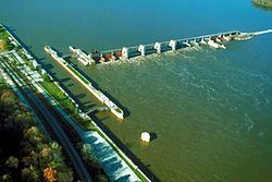
Lock and Dam No. 22 is a lock and dam located near Saverton, Missouri on the Upper Mississippi River around river mile 301.2. The movable portion of the dam is 1,224 feet (373.1 m) long and consists of three roller gates and ten tainter gates. A 1,600 feet (487.7 m) long submersible earthen dike extends to a flood control levee on the Illinois shore. The main lock is 110 feet (33.5 m) wide by 600 feet (182.9 m) long; there is also an incomplete auxiliary lock. In 2004, the facility was listed in the National Register of Historic Places as Lock and Dam No. 22 Historic District, #04000182 covering 1,268 acres (5.1 km2), 1 building, 5 structures, 4 objects.
Map of Lock and Dam No. 22, Saverton Township, MO 63459, USA
When the northern part of Mississippi freezes, near the first week of February, upwards of 20 bald eagles fly down to fish in the churning waters below Lock and Dam No. 22.