
Opening date July 23, 1938 Area 44 ha Added to NRHP 10 March 2004 Impound Upper Mississippi River | Creates Pool 21 Year built 1938 Construction began 1933 | |
 | ||
Location Melrose Township, Adams County, Illinois / Fabius Township, Marion County, Missouri,
near Quincy, Illinois, USA Impounds Upper Mississippi River Length 1,265 feet (385.6 m) (movable portion) Total capacity 62,000 acre·ft (0.076 km) Operator United States Army Corps of Engineers | ||
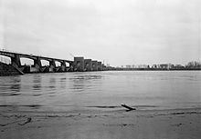
Lock and Dam No. 21 is a lock and dam located at Quincy, Illinois on the Upper Mississippi River around river mile 324.9. The movable portion of the dam is 1,265 feet (385.6 m) long and consists of three roller gates and ten tainter gates. A 1,400 feet (426.7 m) long submersible dike continues to the Missouri shore. The main lock is 110 feet (33.5 m) wide by 600 feet (182.9 m) long and there is also an incomplete auxiliary lock. In 2004, the facility was listed in the National Register of Historic Places as Lock and Dam No. 21 Historic District, #04000181 covering 1,075 acres (4.4 km2), 1 building, 4 structures, 4 objects.
Map of Lock and Dam No. 21, Fabius Township, MO 63471, USA
Currently there is a study being conducted by the city of Quincy to convert Lock & Dam No. 21, 20, and 22 into being hydroelectric by 2016.