
Opening date May 14, 1939 Creates Pool 17 Year built 1939 Construction began 1935 | Length 1,121 feet (341.7 m) Area 35 ha Added to NRHP 10 March 2004 Impound Upper Mississippi River | |
 | ||
Location Jefferson Township & Port Louisa Township, Louisa County, Iowa / New Boston Township, Mercer County, Illinois,
near New Boston, Illinois, USA Impounds Upper Mississippi River Total capacity 50,000 acre·ft (0.062 km) Operator United States Army Corps of Engineers | ||
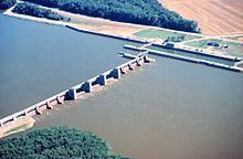
Lock and Dam No. 17 is a lock and dam located near New Boston, Illinois on the Upper Mississippi River near river mile 437. Its main lock is 110 feet (33.5 m) wide and 600 feet (182.9 m) long with its bottom at an elevation of 518 feet (157.9 m). Normal pool elevation behind the dam is 536 feet (163.4 m). The movable portion of the dam is 1,121 feet (341.7 m) long and consists of 3 roller gates and 8 tainter gates. In 2004, the facility was listed in the National Register of Historic Places as Lock and Dam No. 17 Historic District, #04000177 covering 869 acres (3.5 km2), 1 building, 3 structures and 2 objects.
Map of Lock and Dam No. 17, Port Louisa, IA 52653, USA
References
Lock and Dam No. 17 Wikipedia(Text) CC BY-SA