
Max. length 0.75 mi (1.21 km) Surface area 51.4 ha (127 acres) Area 51 ha Number of islands 2 | Max. width 0.5 mi (0.80 km) Surface elevation 91 m Shore length 3.7 km | |
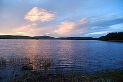 | ||
Lochrutton Loch is a large, lowland freshwater loch that lies to the west of Dumfries, Scotland. The loch trends from north to south and is 0.75 mi (1.21 km) long and 0.5 mi (0.80 km) at its widest point. It has an average depth of 13 ft (4.0 m) and is 58 ft (18 m) at its deepest. The loch was surveyed on 1 May 1905 by James Murray and L.W. Collett as part of Sir John Murray's Bathymetrical Survey of Fresh-Water Lochs of Scotland 1897-1909.
Map of Lochrutton Loch, Dumfries, UK
In the centre of the loch are the remains of a crannog known as Dutton's cairn. It was excavated between 1901 and 1902 and found to have a circular cairn of earth, with a diameter of approximately 80 ft (24 m). The crannog is thought to date from the Early Iron Age and was occupied until the Middle Ages. Finds from the excavation included a jet cross dating from the 13th century.
The loch is populated with bream, perch, pike and roach. No permit is required to fish on the loch.