
Catchment area 8 square miles (21 km) Max. length 1.25 mi (2.01 km) Area 92 ha Length 2.01 km | Primary inflows Surface elevation 16 m Mean depth 1.2 m Width 800 m | |
 | ||
Primary outflows Mill burn at south end in to Waulkmill Bay | ||
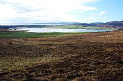
The Loch of Kirbister is a small, shallow, somewhat triangular shaped loch on Mainland Orkney, Scotland, in the parish of Orphir. It lies 5 mi (8.0 km) south west of Kirkwall on cultivated land between two hills. There is a small (37 m (121 ft) by 19 m (62 ft)) turf covered islet known as the Groundwater of Holm just off the eastern shore of the loch. It shows traces in stone of an oval structure and small projecting pier. The loch is popular for trout fishing and the Orkney Trout Fishing Association has a hatchery at the Kirbister pumphouse on the loch edge.
Map of Loch of Kirbister, United Kingdom
Mill Burn, the southerly outflow from the loch, was used to power the 18th century Kirbister Mill.
The loch was surveyed in 1903 by T.N. Johnston and R.C. Marshall and later charted as part of Sir John Murray's The Bathymetrical Survey of Fresh-Water Lochs of Scotland 1897-1909.