
Primary outflows River Avon Max. length 4.8 km (3.0 mi) Average depth 77.27 ft (23.55 m) Length 4.8 km Area 43 ha Width 200 m | Surface area 0.43 km (0.17 sq mi) Max. depth 101 ft (31 m) Surface elevation 724 m Mean depth 24 m Outflow location River Avon, Strathspey | |
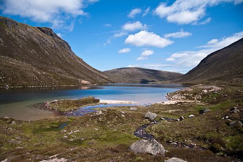 | ||
Loch A'an is an exceedingly remote freshwater loch set deep within the central Cairngorms plateau, in the Cairngorms National Park, located in the eastern Highlands of Scotland. Loch A'an, also called Loch Avon, is the source of the River Avon. Loch A'an is oriented southwest-northeast and is bounded on three sides by precipitous mountains, cliffs and crags, with the North-East opening out to provide an outflow for the river through Glen Avon.
Contents
Map of Loch A'an, Ballater, UK
Geography
To the north of the loch, rising almost vertically, lies the Cairn Gorm, the sixth highest mountain in the United Kingdom. To the southwest of Cairn Gorm, at the head of the loch, lies the imposing peak of Ben Macdui, the second highest mountain in the UK, and to east lies Beinn Mheadhoin, the tenth highest mountain in the UK, again rising almost vertically from the Loch A'an basin. Lying less than 1 mile to the south of the loch and 664 ft (202 m) feet higher up the range at 3,041 ft (927 m), lies Loch Etchachan.