
 | ||
River mouth Confluence with South Platte5,256 ft (1,602 m) Similar South Platte River, Rocky Mountains, Grant‑Frontier Park, Cherry Creek, Boulder Creek | ||
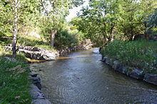
Little Dry Creek is a short tributary of the South Platte River, approximately 10 miles (16 km) long, in Arapahoe County, Colorado in the United States. The creek drains a suburban area south of Denver and is interrupted by the Englewood Dam. It rises in Centennial, Arapahoe County, west of I-25, and flows generally northwest into Englewood. It has historically been used for irrigation and feeds an aqueduct that runs parallel to it. The creek flows into South Platte just south of West Dartmouth Avenue approximately two tenths of a mile west of its intersection with Santa Fe Drive which is US 85.
Map of Little Dry Creek, Englewood, CO, USA
The Little Dry Creek Trail intersects the Highline Canal Trail in Cherry Hills Village.
The mouth of the creek is noted as the location of the first significant gold discovery in present-day Colorado. In the first week of July 1858, Green Russell and his brothers discovered a gold pocket that yielded several hundred dollars' worth of gold. The discovery set off the Colorado Gold Rush in the following year.