
Primary outflows Dell Creek Surface area 249 acres (101 ha) Surface elevation 1,767 m Mean depth 25 m Inflow source Dell Creek | Primary inflows Average depth 82.4 ft (25.1 m) Area 101 ha Outflow location Dell Creek | |
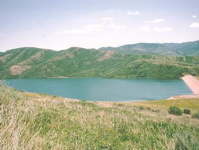 | ||
Little Dell Reservoir is a reservoir in eastern Salt Lake County, Utah, United States, about 13 miles east of Salt Lake City in the western Wasatch Mountains. It is located alongside Utah State Route 65, about 1 mile northeast of Interstate 80. Little Dell is an impoundment on Dell Creek, but it also stores water diverted from Parleys Creek located immediately downstream. The reservoir was constructed between 1987 and 1993 for drinking water supply and flood control as a joint venture between the U.S. Army Corps of Engineers, Metropolitan Water District of Salt Lake City and Salt Lake County. The total cost of the project was US$63,864,932.00. The reservoir and recreation area is operated and maintained by the Salt Lake City Department of Public Utilities.
Map of Little Dell Reservoir, Utah 84108, USA
Construction of a storage facility on Dell Creek in Parleys Canyon, Salt Lake County, Utah was first considered in the late 1940s when Dr. Ray E. Marsell, geologist consultant for the Utah Water and Power Board, recommended the project to the Salt Lake City Commission. Interest in the project was rekindled in 1983 when 1300 South, Salt Lake City was flooded for the second time in 31 years.
The Little Dell Reservoir dam is a rolled earthfill structure. It has a maximum height of 224 feet above the streambed and is 1,700 feet in length.
The recreation area at Little Dell is located near the site of a historic Pony Express station run by Utah pioneer Ephraim Hanks in the mid-19th century. Known as Little Dell Station, it was situated about 1000 feet northeast of the northernmost tip of the reservoir. The site was listed on the National Register of Historic Places in 1971. None of the original structure remains.
Unlike nearby Mountain Dell Reservoir, fishing is currently allowed in Little Dell Reservoir. Little Dell contains Brook trout, Brown trout, and native Bonneville cutthroat trout. Special fishing regulations exist to protect the latter species. Access to the reservoir is only allowed through the recreation area. Because Little Dell is a watershed, there is no swimming, bathing or washing allowed within the reservoir. Motorized boats are also not permitted. Windsurfing is only allowed with a full drysuit. Standup paddleboarding (SUP) is not allowed.
Little Dell Reservoir can be best viewed from Little Mountain Pass, located at the top of Emigration Canyon.