
 | ||
Fjords in Canada, (fiords in Canada), are long, narrow inlets characterized by steep sides, created in a valley carved by glacial activity. A fjord can have two or more basins separated by sills. The bowls can have a depth of 20 to 500 m (66 to 1,640 ft) and the dividing sills can raise up to a few metres below the water surface. Mountainous glaciated areas in Canada are along the British Columbia Coast: from the Alaskan border along the Portland Canal to Indian Arm. Kingcome Inlet is a typical West Coast fjord.
Lesser fjords in Canada are located along the coastline of Newfoundland and Labrador such as Saglek Fjord, Nachvak Fjord, Anaktalâk Bay, Western Brook Pond, Hebron Fjord, and Bonne Bay in Gros Morne National Park.
Quebec's Saguenay River valley contains a fjord. The Saguenay Fjord is 100 km (62 mi) long and 275 m (902 ft) deep.
The Canadian Arctic Archipelago also features fjords such as those around Ellesmere and Baffin Island, including Alexandra Fjord, Ellesmere Island, and Sam Ford Fiord, Baffin Island.
When a portion of the high cliff wall falls off, it may cause a tsunami. This occurred in the early 20th century at Western Brook Pond of Gros Morne National Park when a 30 m (98 ft) tsunami was created after Broke Off Cliff fell.
In this listing, a fjord may consist of several complex waterways. These waterways may contribute to the length of the fjord. For more information on these please see the main fjord source or Wikipedia article. Some examples are Dean Channel and Douglas Channel. The locality of Hagensborg in the Bella Coola Valley in the Dean Channel fjord was settled by Norwegian immigrants in 1894 as it reminded them of home. The total length of the fjord from the head of Dean Channel to the mouth of Fitz Hugh Sound is about 170 km (110 mi) rivalling Hardangerfjord in Norway for length. The Hardangerfjord, the Queen of fjords, at a length of 179 km (111 mi) is claimed to be fourth largest fjord in the world and second largest of Norway.
Anaktalak Fjord, Saglek Fjord and Nachvak Fjord off the coast of Newfoundland and Labrador are being studied for environmental changes due to global warming. Increased tourism and marine traffic, contaminants from air, water or industrial pollution, changing weather patterns are affecting what once had been pristine water basins of the fjords protected by sills.
According to the article, Portland Canal, the use of the word canal to name fjords/inlets on the British Columbia Coast and the Alaska Panhandle is a legacy of the Spanish exploration of the area in the 18th century. For example, Haro Strait between Victoria and the San Juan Islands was originally Canal de Haro. The English cognate to the Spanish canal is "channel", which is found throughout the coast, cf. Dean Channel.
The article, Sechelt Inlet, states that fjords on the British Columbia Coast have rapids, which are termed skookumchucks which means strong waters (tidal rapid) in Chinook Jargon, the old coastal trade language). Skookumchuks are caused by the typical shallows near the mouth of a fjord as the volume of water inside the fjord's depths tries to pour out to, or in from, the more open waters beyond.
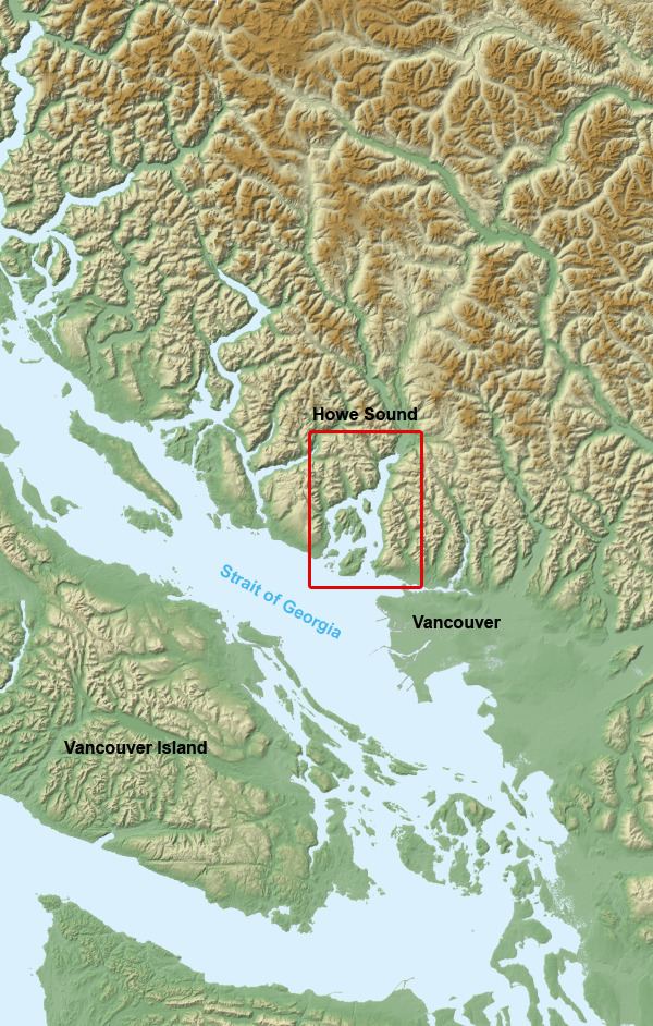
The phenomenon of Mountain-gap wind or squamish or outflow affects the fjords of Canada and Norway. The outflow winds at the Salt and Bols fjords of Norway and the Howe Sound and Portland Inlet of Canada have been compared. European winds may be termed Bora. The cold dry air of the continental interior seeks out the easier passage through the fjord valley creating hurricane-force winds.
According to the definition, fjord, Western Brook Pond, in Newfoundland's Gros Morne National Park, is also often described as a fjord, but is actually a freshwater lake cut off from the sea, so is not a fjord in the English sense of the term. Such lakes are sometimes called "fjord lakes". It is of interest to note that Pissing Mare Falls at 350 m (1,150 ft) high, is one of several waterfalls to drain into Western Brook Pond, Along the British Columbia Coast, a notable fjord-lake is Owikeno Lake, which is a freshwater extension of Rivers Inlet.