
Location State of Alaska | Government Borough government | |
 | ||
Number 19 Organized boroughs
10 Census areas Populations (Organized boroughs):452 (Yakutat) – 291,826 (Anchorage)
(Census areas):2,150 (Hoonah-Angoon) – 17,013 (Bethel) Areas (Organized boroughs):452 square miles (1,170 km) (Skagway) – 88,817 square miles (230,030 km) (North Slope)
(Census Areas):3,760 square miles (9,700 km) (Prince of Wales-Hyder) – 145,900 square miles (378,000 km) (Yukon-Koyukuk) Subdivisions Communities, consolidated city-county | ||
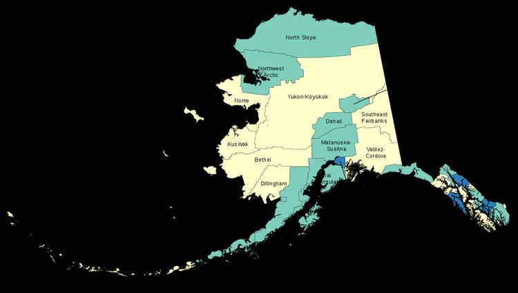
The U.S. state of Alaska is divided into 19 organized boroughs and one "Unorganized Borough". Alaska and Louisiana are the only states that do not call their first-order administrative subdivisions counties (Louisiana uses parishes instead).
Many of the most densely populated regions of the state are part of Alaska's boroughs, which function similarly to counties in other states. However, unlike county equivalents in the other 49 states, the organized boroughs do not cover the entire land area of the state. The area not part of any organized borough is referred to as the unorganized borough. The U.S. Census Bureau, in cooperation with the state, divides the Unorganized Borough into 10 census areas, each roughly corresponding to an election district, thus totaling 29 county equivalents. However, these areas exist solely for the purposes of statistical analysis and presentation. They have no government of their own. Boroughs and census areas are both treated as county-level equivalents by the Census Bureau.
Some areas in the unorganized borough receive limited public services directly from the Alaska state government, usually law enforcement from the Alaska State Troopers and educational funding.
Six consolidated city-county governments exist—Juneau City and Borough, City and Borough of Haines, Sitka City and Borough, Yakutat City and Borough, Wrangell City and Borough, as well as the state's largest city, Anchorage. Though its legal name is the Municipality of Anchorage, it is considered a consolidated city-borough under state law.
The Federal Information Processing Standard (FIPS) 55-2,3,4 codes, which are used by the United States Census Bureau to uniquely identify states and counties, is provided with each entry. Alaska's code is 02, so each code is of the format 02XXX. The FIPS code for each county links to census data for that county.
Census areas in the Unorganized Borough
The Unorganized Borough is the portion of the U.S. state of Alaska not contained in any of its 19 organized boroughs. It encompasses over half of Alaska's area, 970,500 km² (374,712 mi²), an area larger than any other U.S. state. As of the 2000 census 13% of Alaskans (81,803 people) reside in it.
Currently unique among the United States, Alaska is not entirely subdivided into organized county equivalents. (South Dakota and Texas are among states that in the past have had unorganized counties.) For the 1980 census, the United States Census Bureau divided the unorganized borough into 12 census areas to facilitate census taking in the vast unorganized area. As new boroughs incorporate, these areas have been altered or eliminated to accommodate, such that there are currently 10 census areas: