
Time zone CET/CEST (UTC+1/+2) Area 23.6 km² Local time Saturday 11:21 AM Dialling code 07247 | Elevation 110 m (360 ft) Postal codes 76351 Population 11,883 (31 Dec 2008) Postal code 76351 | |
 | ||
Weather 8°C, Wind SW at 27 km/h, 94% Humidity | ||
Linkenheim-Hochstetten is a municipality in the district of Karlsruhe, in Baden-Württemberg, Germany. It is situated on the right bank of the Rhine, 17 km north of Karlsruhe.
Map of 76351 Linkenheim-Hochstetten, Germany
The towns of Linkenheim and Hochstetten merged their municipal governments 1975, newly elected burgermeister (21.01.2007): Günther Johs.
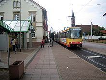
The town is served by routes S1 and S11 of the Karlsruhe Stadtbahn, which is operated by the Albtal-Verkehrs-Gesellschaft over the Hardtbahn. Seven stops are served, at Linkenheim Süd, Linkenheim Friedrichstrasse, Linkenheim Rathaus, Linkenheim Schulzentrum, Hochstetten Grenzstrasse, Hochstetten Altenheim and Hochstetten.
References
Linkenheim-Hochstetten Wikipedia(Text) CC BY-SA