
Easiest route Paved road, hike | Elevation 156 m | |
 | ||
Similar Mayon, Malinao Volcano, Mount Masaraga, Mount Isarog, Mount Bulusan | ||
Lignon hill nature park legazpi city albay
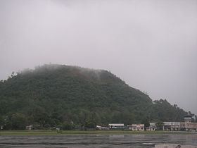
Ligñon Hill is a prominent hill in the city of Legazpi, some 3 kilometers west of its downtown port area in Albay, Philippines. The summit rises to about 512 feet (156 meters), overlooking the Mayon Volcano to the northwest and the entire city and Albay Gulf to the east. The whole site is managed by the city and provincial government, and has been designated as a Nature Park.
Contents
- Lignon hill nature park legazpi city albay
- Map of LigC3B1on Hill Philippines
- Ligon Hill Nature Park
- References
Map of Lig%C3%B1on Hill, Philippines
Ligñon Hill is a prehistoric cinder cone near the foot of Mayon, some 12 kilometers south-southeast of the volcano's summit. It is mainly composed of dolerite and basaltic volcanic rocks. Except for Mayon Volcano, it is the highest point in the city situated next to the Legazpi Airport in barangay 41 (Bogtong) near the city's border with the municipality of Daraga. It hosts the Mayon Volcano Observatory, the central monitoring station of the Philippine Institute of Volcanology and Seismology built in 1989.
Ligñon Hill Nature Park
In 2006, the park underwent a major renovation with the hilltop leased for private development under a memorandum of agreement with the Albay provincial government. The park now has a viewing deck with coin-operated telescopes, a landscaped promenade as well as restaurants and souvenir shops. Other features include a zipline and a 50-foot tunnel constructed by the Japanese during World War II. It is accessible by car via a spiral uphill road off Binitayan Road from the Legazpi Airport.