
Area rank 277 in Norway Area 301 km² | Administrative centre Lierbyen Demonym(s) Liung Local time Friday 9:42 AM | |
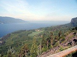 | ||
Weather 5°C, Wind SW at 14 km/h, 57% Humidity Points of interest Svangstrand, Asdøljuvet, Finnemarka | ||
Lier norway
Lier is a municipality in Buskerud county, Norway. The administrative centre of the municipality is the village of Lierbyen. The municipality of Lier was established on 1 January 1838 (see formannskapsdistrikt). The area Åssiden was transferred from Lier to the neighboring municipality of Drammen on 1 July 1951.
Contents
- Lier norway
- Map of Lier Norway
- Name
- Coat of arms
- Geography
- Notable residents
- Attractions
- Sister cities
- References
Map of Lier, Norway
Norway's longest indoor shopping center, Liertoppen, is located in Lierskogen.
Name
The Old Norse form of the name was Líðir. The name is the plural form of líð which means "hillside".
Coat-of-arms
The coat-of-arms is from modern times and was designed by Hallvard Trætteberg. They were granted on 14 August 1970. The arms show five silver-colored apple blossoms on a red background. The area is well known for the production of various types of fruit, berries, vegetables, and flowers, so this was chosen as a symbol of the area's lush scenery and agriculture.
Geography
Lier borders to the municipalities of Asker and Bærum (in Akershus county) and Drammen, Modum, Nedre Eiker, Røyken and Hole (in Buskerud county). It includes the villages of Lierbyen, Sylling, Sjåstad, Nøste, Gullaug, Lierskogen, and Tranby.
Lier is thought of as a "green lung" for Norway's capital, Oslo, with its vast number of fields and apple trees. It is also famous for its agricultural products as strawberries and vegetables.
The Gilhusodden Nature Preserve is home of many different bird species. The area is also used for recreation, especially swimming and sunbathing, with its long, shallow beach.
Notable residents
Attractions
Sister cities
The following cities are twinned with Lier: