
Lake type Natural lake Surface elevation 2,372 m | Primary inflows Basin countries United States Outflow location Lewis River | |
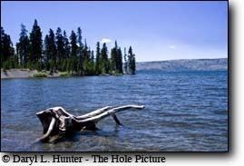 | ||
Lewis Lake is located in the U. S. state of Wyoming in the southern part of Yellowstone National Park, about 4 miles (6.4 km) southeast of Shoshone Lake, and approximately 10 miles (16 km) southwest of Yellowstone Lake. Lewis Lake and Shoshone Lake are both located a few miles northeast of the Pitchstone Plateau.
Map of Lewis Lake, Wyoming 82190, USA
The Lewis River is the lake's primary inflow, draining south from Shoshone Lake. The primary outflow of Lewis Lake is also the Lewis River, continuing south to join the Snake River near the southern boundary of Yellowstone National Park. A few small creeks also feed Lewis Lake. There are several hot springs emptying into the lake on its northwestern shore and two more hot springs at the lake's southern end where it empties into the Lewis River. A campground is located on the lake's southeast shore. Yellowstone National Park's South Entrance Road (which is also numbered as U.S. Route 287, U.S. Route 89, and U.S. Route 191), run along the east side of Lewis Lake.
Like the river, Lewis Lake is named for Meriweather Lewis, commander of the Lewis and Clark Expedition