
Population 65 (2001 census) Sovereign state United Kingdom Dialling code 01993 | OS grid reference SP3206 | |
 | ||
Lew is a small village within the civil parish of Curbridge and Lew, located about 2.5 miles (4 km) southwest of Witney in West Oxfordshire.
Contents
Map of Lew, Bampton, UK
History
Evidence of early human habitation in the parish includes a tumulus, probably Anglo-Saxon, on a 350 feet (110 m) high hill west of the village. The name of the village, recorded as Hlæwe in 984, means "tumulus" in Old English.
Until the 19th century Lew was a township in the parish of Bampton. It became a separate ecclesiastical parish in 1857, known as Bampton Lew. The parish was united with Bampton in 1917, and since 1976 has formed part of the benefice of Bampton with Clanfield.
Lew was made a separate civil parish in 1866.
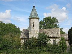
Parish church
The Church of England parish church of the Holy Trinity was designed in a 13th-century style by the architect William Wilkinson and built in 1841.
Natural history
The parish is a mix of arable land and pasture with small woodlands such as Lew Gorse. There are species of persecuted mammal in the area including dog walkers roe deer, muntjac deer, badger, fox, hare and rabbit. Amongst bird species, the kestrel, common buzzard, barn owl, and tawny owl are the predominant predators. Other birds include greater spotted woodpecker, European green woodpecker, lapwing and goldfinch. Game birds include red-legged partridge, common pheasant and wood pigeon.