
Elevation 260 m (850 ft) Local time Wednesday 12:09 PM | Time zone CET/CEST (UTC+1/+2) Population 1,269 (31 Dec 2008) | |
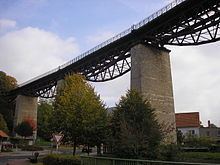 | ||
Weather 12°C, Wind W at 16 km/h, 63% Humidity Points of interest Erlebnis Draisine, Historisches Pfarrhaus Lengenfe, Eisenbahnviadukt | ||
Lengenfeld unterm Stein (or Lengenfeld/Stein) is a village and a former municipality in the Unstrut-Hainich district of Thuringia, Germany. Since 1 December 2011, it is part of the municipality Südeichsfeld.
Map of Lengenfeld unterm Stein, Germany
References
Lengenfeld unterm Stein Wikipedia(Text) CC BY-SA