
Elevation 353 m Local time Tuesday 8:01 PM | Area 22.25 km² Neighborhoods Vrbka, Sychrov, Souboř | |
 | ||
Weather 7°C, Wind W at 5 km/h, 77% Humidity Team FK Kovofiniš Ledeč nad Sázavou | ||
Prohl dka koly 70 let gymn zia lede nad s zavou
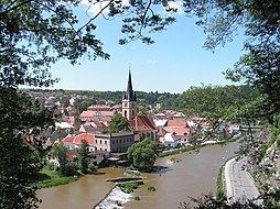
Ledeč nad Sázavou ( [ˈlɛdɛtʃ ˈnatsaːzavou̯]) is a town in the Vysočina Region, Czech Republic. It is located at around 49°41′45″N 15°16′30″E. The Sázava River flows through the town.
Contents
- Prohl dka koly 70 let gymn zia lede nad s zavou
- Map of 584 01 LedeC48D nad SC3A1zavou Czechia
- Cyklov let lede nad s zavou stvo idla sv tl nad s zavou
- History
- References
Map of 584 01 Lede%C4%8D nad S%C3%A1zavou, Czechia
Cyklov let lede nad s zavou stvo idla sv tl nad s zavou
History
Until 1918, the town was part of the Austrian monarchy (Austria side after the compromise of 1867), in the district of the same name, in Bohemia.
A post-office was opened in 1852 (named Ledetsch).
References
Ledeč nad Sázavou Wikipedia(Text) CC BY-SA